Marine Geophysical Survey
Geophysical Survey Services
Geophysical surveys play a vital role in the early stages of development and infrastructure projects. They serve as critical investigation tools prior to the commencement of major engineering, marine construction, or energy exploration works.
Core Survey Technologies
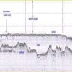
1. Side Scan Sonar
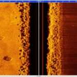
Side scan sonar—also known as side-imaging or side-looking sonar—is typically towed behind a survey vessel. It captures high-resolution, near-photographic images of the seabed across hundreds of meters on each side, enabling rapid and accurate mapping of large underwater areas.
Applications:
Seabed characterization
Debris detection
Wreck and pipeline location
Port and harbor planning
2. Seismic Surveys
Seismic methods are the most widely used geophysical tools in geological and engineering surveys. They provide detailed imaging of subsurface layers by analyzing how seismic waves reflect and refract through the ground.
Applications:
Oil & gas exploration
Mineral surveys
Fault mapping
Foundation and subsurface modeling
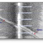
3. Magnetometer Surveys
Magnetometers detect variations in the Earth’s magnetic field, identifying buried ferrous objects of all sizes. These surveys are essential in marine and archaeological investigations.
Detectable Objects:
Anchors, chains, and pipelines
Ballast stones, shipwreck debris
Munitions, engines, aircraft parts
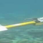
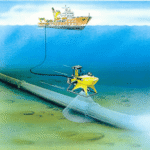
4. Remote Operated Vehicles (ROVs)
ROVs are tethered, mobile underwater robots used for detailed visual inspection and sensor-based surveys.
Class I: Observation only
Class II: Observation with payload (e.g., sonar, cameras)
Applications:
Pipeline and cable surveys
Jacket and subsea structure inspections
Hull inspections of vessels
Additional Geophysical Methods
| Method | Primary Purpose |
|---|---|
| Electrical Resistivity | Void, groundwater, and contamination detection |
| Electromagnetic (EM) | Subsurface conductivity mapping |
| Gravity | Mapping large geological features and density anomalies |
| Magnetotelluric (MT) | Deep subsurface and geothermal exploration |
Survey Applications by Industry
Geophysical services are tailored for a wide range of engineering and marine applications, including:
Land Reclamation & Coastal Engineering:
Sand/Cap Rock surveys for beach replenishmentPort & Harbor Development:
Feasibility studies for ports, power plants, desalination facilitiesDredging Support:
Pre- and post-dredging/channel access surveysMarine Infrastructure:
Seabed and pre-engineering surveys for pipelines, bridges, and jettiesOffshore Energy:
Pre-lay, pre-construction, and anchor clearance surveysSalvage & Debris Recovery:
Surveys to locate lost subsea assets such as anchors, cutter heads, chains, pipelines, and shipwrecks